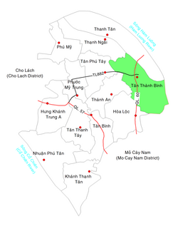
Tân Thành Bình
Appearance
Tân Thành Bình
Xã Tân Thành Bình | |
|---|---|
Commune and Village | |
 Location in Mỏ Cày Bắc District | |
| Coordinates: 10°11′45″N 106°19′53″E / 10.19583°N 106.33139°E | |
| Country | |
| Region | Mekong Delta |
| Province | Bến Tre |
| District | Mỏ Cày Bắc |
| Area | |
• Total | 7.08 sq mi (18.33 km2) |
| Population (1999) | |
• Total | 12,968 |
| • Density | 1,830/sq mi (707/km2) |
| Time zone | UTC+07:00 (Indochina Time) |
| Postal code | 28918 |
Tân Thành Bình is a rural commune of Mỏ Cày Bắc District, Bến Tre Province, Vietnam. The commune covers 18.33 km2, with a population of 12,968 in 1999, and a population density of 707 inhabitants/km2.[1]
References
[edit]- ^ "List of populated places in Vietnam". Ministry of Information and Communications of Vietnam. Archived from the original on 2013-03-24. Retrieved 2012-08-30.


