Maca District
Appearance
Maca
Maqa | |
|---|---|
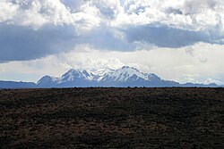
 Hualca Hualca, Maca District | |
 | |
| Country | |
| Region | Arequipa |
| Province | Caylloma |
| Capital | Maca |
| Government | |
| • Mayor | Hugo Eulogio Apaza Nina |
| Area | |
| • Total | 227.48 km2 (87.83 sq mi) |
| Elevation | 3,262 m (10,702 ft) |
| Population | |
| • Total | 1,307 |
| • Density | 5.7/km2 (15/sq mi) |
| Time zone | UTC-5 (PET) |
| UBIGEO | 040512 |
Maca District is one of twenty districts of the province Caylloma in Peru.[1]
-
Colca River on the northern border of the Maca District
-
Souvenir sellers west of Maca
-
the church in Maca
-
The church in Maca (altar)
See also
[edit]References
[edit]- ^ (in Spanish) Instituto Nacional de Estadística e Informática. Banco de Información Distrital Archived 2008-04-23 at the Wayback Machine. Retrieved April 11, 2008.
15°38′33″S 71°46′12″W / 15.6425°S 71.7699°W


