Norsälven
Appearance
You can help expand this article with text translated from the corresponding article in Swedish. (March 2022) Click [show] for important translation instructions.
|
| Norsälven | |
|---|---|
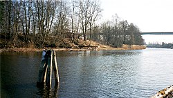
 Norsälven at Älvenäs | |
 | |
| Location | |
| Country | Sweden |
| County | Värmland |
| Physical characteristics | |
| Source | Fryken |
| • elevation | 62 m (203 ft) |
| Mouth | Vänern |
• coordinates | 59°21′50″N 13°11′10″E / 59.36389°N 13.18611°E |
• elevation | 44 m (144 ft) |
| Length | 180 km (110 mi)[1] |
| Basin size | 4,160 km2 (1,610 sq mi)[1] |
| Discharge | |
| • average | 56 m3/s (2,000 cu ft/s)[1] |
| • maximum | 192 m3/s (6,800 cu ft/s) |
| Basin features | |
| Tributaries | |
| • left | Rottnan, Röjdan |
| • right | Ljusnan River |
Norsälven (Swedish pronunciation: [ˈnûːʂˌɛlːvɛn])[2] is a river flowing between Fryken and Vänern in Värmland, Sweden. It used to be an important river for log driving. During the 1950s, there were 6.23 million logs annually floating in the river. The length is 28 km (including Ljusnan River, 179 km).
References
- ^ a b c "Norsälven". Nationalencyklopedin (in Swedish). Retrieved 3 August 2010. (subscription required)
- ^ Jöran Sahlgren; Gösta Bergman (1979). Svenska ortnamn med uttalsuppgifter (in Swedish). p. 18.
