Alluvial City, Louisiana
Appearance
Alluvial City | |
|---|---|
| Coordinates: 29°50′29″N 89°41′29″W / 29.84139°N 89.69139°W | |
| Country | |
| State | |
| Parish | |
| MCD | District E |
| Established | 19th century |
| Elevation | 0.9 m (3 ft) |
| Time zone | UTC−6 (Central) |
| • Summer (DST) | UTC−5 (Central) |
| ZIP code | 70085 |
| Area code | 504 |
| GNIS feature ID | 559767 |
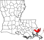
Alluvial City is an Isleño fishing community in St. Bernard Parish, Louisiana, United States.[1] The community is located on the western bank of Bayou la Loutre. Alluvial City is connected to the neighboring community of Yscloskey by the Bayou la Loutre lift bridge, also known as the Yscloskey bridge.[2]
In popular culture
The community was the inspiration for the literary work Alluvial Cities: Poems.[3]
References
- ^ "Alluvial City". Geographic Names Information System. United States Geological Survey, United States Department of the Interior. Retrieved August 29, 2021.
- ^ Broach, Drew (August 7, 2015). "29 historic bridges of southeast Louisiana". The Times-Picayune. Archived from the original on September 15, 2021. Retrieved September 15, 2021.
- Parker, Halle (August 31, 2021). "Destroyed by Hurricane Katrina, St. Bernard Parish fares much better than others in Ida". NOLA. Archived from the original on August 31, 2021. Retrieved September 15, 2021. - ^ Hannan, Christopher M. Alluvial Cities: Poems. Texas A&M University Press. Retrieved October 4, 2021.[dead link]


