Vrancea Mountains


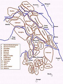
The Vrancea Mountains (Template:Lang-ro) are a mountain range in the Curvature Carpathians in Romania. Located mostly in western Vrancea County, they also cover parts of Bacău, Buzău, and Covasna counties.
The highest peak is Goru Peak, at 1,784.6 metres (5,855 feet).
To the south are the Penteleu and Ivănețu Massifs (part of the Buzău Mountains), while to the north are the Tarcău Mountains, separated from the Vrancea Mountains by the Trotuș River.
The Vrancea Mountains are a habitat for a large number of animals, including brown bears, red foxes, deer, wild boars, Carpathian lynxes, stone martens, gray wolves, wild cats, and hares, as well as birds such as capercaillies, warblers, vultures, golden eagles, lesser spotted eagles, eagle-owls, tawny owls, long-eared owls, ravens, ring ouzels, black woodpeckers, green woodpeckers, and jays.
The 1977 Vrancea earthquake had its epicentre in these mountains.[1]
References
- ^ Pandea, Razvan-Adrian (2 July 2016). "4 March 1977 Earthquake". Agerpres.
