Nandulehe
Appearance
Nandulehe Town
南独乐河镇 | |
|---|---|
 Section of the Great Wall north of Emeishan Village, 2008 | |
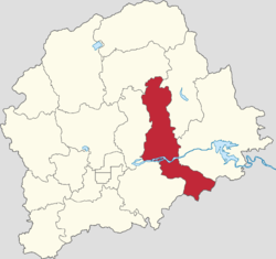
 Location within Pinggu District | |
| Coordinates: 40°10′17″N 117°13′14″E / 40.17139°N 117.22056°E | |
| Country | China |
| Municipality | Beijing |
| District | Pinggu |
| Village-level Divisions | 13 villages |
| Area | |
| • Total | 69.45 km2 (26.81 sq mi) |
| Elevation | 58 m (190 ft) |
| Population (2020) | |
| • Total | 18,847 |
| • Density | 270/km2 (700/sq mi) |
| Time zone | UTC+8 (China Standard) |
| Postal code | 101212 |
| Area code | 010 |
Nandulehe Town (simplified Chinese: 南独乐河镇; traditional Chinese: 南獨樂河鎮; pinyin: Nándúlèhé Zhèn) is a town loctated on the eastern Pinggu District, Beijing, China. Situated on the banks of Ju River, It borders Xiong'erzhai and Huangsongyu Townships in the north, Jinhaihu Town in the east, Xujiatai Township in the south, as well as Xiagezhuang and Shandongzhuang Towns in the west . It had 18,847 people residing within its borders as of 2020.[1]
History
| Year | Status | Belonged to |
|---|---|---|
| 1956 - 1958 | Nandulehe Township | Pinggu County, Hebei |
| 1958 - 1961 | Hanzhuang People's Commune | Pinggu County, Beijing |
| 1961 - 1984 | Nandulehe People's Commune | |
| 1984 - 1990 | Nandulehe Township | |
| 1990 - 2002 | Nandulehe Town | |
| 2002 - present | Pinggu District, Beijing |
Administrative divisions
At the time of writing, Nandulehe Town is subdivided into the following 13 villages:[3]
| Subdisvision Names | Name Transliterations |
|---|---|
| 南独乐河 | Nan Dulehe |
| 北独乐河 | Bei Dulehe |
| 刘家河 | Liujiahe |
| 峨嵋山 | Emeishan |
| 北寨 | Beizhai |
| 公爷坟 | Gongyefen |
| 峰台 | Fengtai |
| 张辛庄 | Zhangxinzhuang |
| 望马台 | Wangmatai |
| 甘营 | Ganying |
| 南山村 | Nanshancun |
| 新农村 | Xinnongcun |
| 新立村 | Xinlicun |
See also
References
- ^ "(北京市)平谷区第七次全国人口普查公报-红黑统计公报库". tjgb.hongheiku.com. Retrieved 2022-10-27.
- ^ Zhong hua ren min gong he guo zheng qu da dian. Bei jing shi juan. Li li guo, Li wan jun, Wu shi min, 李立国., 李万钧., 吴世民. Bei jing: Zhong guo she hui chu ban she. 2013. ISBN 978-7-5087-4058-4. OCLC 910451741.
{{cite book}}: CS1 maint: others (link) - ^ "2021年统计用区划代码和城乡划分代码". www.stats.gov.cn. Retrieved 2022-10-27.


