Jump to content

Arorangi

Coordinates: 21°13′17″S 159°49′37″W / 21.221381°S 159.82687°W / -21.221381; -159.82687
From Wikipedia, the free encyclopedia

This is the current revision of this page, as edited by Schwede66 (talk | contribs) at 07:54, 13 February 2023 (script-assisted date audit and style fixes per MOS:NUM). The present address (URL) is a permanent link to this version.

(diff) ← Previous revision | Latest revision (diff) | Newer revision → (diff)

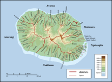
Districts and tapere on Rarotonga.

Arorangi is one of the five districts that make up the island of Rarotonga in the Cook Islands.[1] It is located in the west of the island, to the northwest of the district of Titikaveka, and southwest of the district of Avarua.

References

[edit]
  1. ^ "Official Map of Rarotonga". Cook Islands Ministry of Justice. Retrieved 10 August 2020.

21°13′17″S 159°49′37″W / 21.221381°S 159.82687°W / -21.221381; -159.82687