Jump to content

Arey Lagoon

Coordinates: 70°05′23″N 143°52′44″W / 70.08972°N 143.87889°W / 70.08972; -143.87889
From Wikipedia, the free encyclopedia

This is the current revision of this page, as edited by SimLibrarian (talk | contribs) at 17:35, 27 February 2023. The present address (URL) is a permanent link to this version.

(diff) ← Previous revision | Latest revision (diff) | Newer revision → (diff)
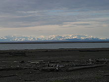
Brooks Range from Arey Island on the Alaska North Slope

Arey Lagoon is a bay on the Beaufort Sea coast of the U.S. state of Alaska. It is 7 miles (11 km) across and located between Arey Island and the mainland North Slope.[1]

References

[edit]
  1. ^ "Arey Lagoon". Geographic Names Information System. United States Geological Survey, United States Department of the Interior.

70°05′23″N 143°52′44″W / 70.08972°N 143.87889°W / 70.08972; -143.87889