Nawojowa
You can help expand this article with text translated from the corresponding article in Polish. (April 2021) Click [show] for important translation instructions.
|
This article needs additional citations for verification. (July 2019) |
Nawojowa | |
|---|---|
Village | |
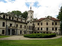
 Stadnicki Palace | |
| Coordinates: 49°33′34″N 20°44′31″E / 49.55944°N 20.74194°E | |
| Country | |
| Voivodeship | Lesser Poland |
| County | Nowy Sącz County |
| Gmina | Nawojowa |
| Area | 51.13 km2 (19.74 sq mi) |
Nawojowa [navɔˈjɔva] is a village in Nowy Sącz County, Lesser Poland Voivodeship, South Poland. It belongs to the gmina (administrative district) called Gmina Nawojowa. It is approximately 8 kilometres (5 mi) south-east of Nowy Sącz and 81 km (50 mi) south-east of the regional capital Kraków.[1]
History
Early history
Nawojowa was founded by Nawoj of Tęczyn, Castellan of Krakow. In later years, it fell into the hands of Dukes Ostrogski and was part of Ostrogski's fee tail (ordynacja). In 1600 it was transferred to Lubomirskis. At that time it also included 25 settlements laid in the mountains: Szlachtowa, Czarnowoda, Jaworki, Białowoda (today Gmina Szczawnica), Kunina, Bończa, Łazy, Popardowa, Margoń, Rybień, Homrzyska, Złotne, Czaczów, Barnowiec, Roztoka, Składziste, Maciejowa, Łabowa, Lachowiec, Kotów, Młyn, Nowa Wieś, Łosie, Krzyżówka, and Frycowa. In 1793 the property was split and Nawojowa was allotted to Duke Lubomirski, starost of Olsztyn.


