Piława, Szczecinek County
Appearance
Piława | |
|---|---|
Village | |
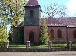
 Saints Peter and Paul church in Piława | |
| Coordinates: 53°N 16°E / 53°N 16°E | |
| Country | |
| Voivodeship | West Pomeranian |
| County | Szczecinek |
| Gmina | Borne Sulinowo |
| Time zone | UTC+1 (CET) |
| • Summer (DST) | UTC+2 (CEST) |
| Vehicle registration | ZSZ |
| National roads | |
Piława [piˈwava] (German: Pielburg)[1] is a village in the administrative district of Gmina Borne Sulinowo, within Szczecinek County, West Pomeranian Voivodeship, in north-western Poland.[2] It is situated on the northwestern shore of Lake Pile in the historic region of Pomerania.
History
In the 10th century, the area became part of the emerging Polish state under its first historic ruler Mieszko I. Following the fragmentation of Poland into smaller duchies, it became part of the Duchy of Pomerania. From 1701, it was part of the Kingdom of Prussia, and from 1871 to 1945 it was also part of Germany. Following Germany's defeat in World War II, in 1945, it became again part of Poland.
References
- ^ M. Kaemmerer (2004). Ortsnamenverzeichnis der Ortschaften jenseits von Oder u. Neiße (in German). ISBN 3-7921-0368-0.
- ^ "Central Statistical Office (GUS) - TERYT (National Register of Territorial Land Apportionment Journal)" (in Polish). 2008-06-01.


