Non Charoen
Appearance
Non Charoen
โนนเจริญ | |
|---|---|
Subdistrict municipality | |
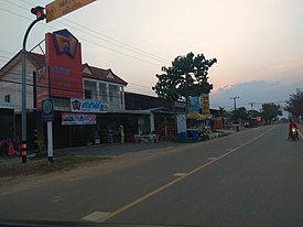
 Road in Non Charoen | |
| Coordinates: 14°29′6.5″N 103°11′5.3″E / 14.485139°N 103.184806°E | |
| Country | |
| Province | Buriram |
| District | Ban Kruat |
| Tambon | Non Charoen |
| Government | |
| • Type | Local government |
| • Mayor | Somjai Khamapanya |
| Area | |
| • Total | 21.679 km2 (8.370 sq mi) |
| Elevation | 181.9 m (596.8 ft) |
| Population (2020) | |
| • Total | 8,563 [1] |
| • Density | 392/km2 (1,020/sq mi) |
| Time zone | UTC+7 (Thailand Standard Time) |
| Area code | 044 |
| Website | www |

Non Charoen (Thai: โนนเจริญ) is a subdistrict municipality (thesaban tambon) in Buriram Province, Thailand. The town covers the whole subdistrict (tambon) Non Charoen of Ban Kruat district.
History
The local government unit was established effective February 21 1997 as a subdistrict administrative organization (SAO). [2] On October 27 2009 it was upgraded to a subdistrict municipality.
Territory
- Northern bordering Tambon Khao Din Nuea
- Eastern bordering Khao Din Nuea, Khok Klang Amphoe Phanom Dong Rak Surin Province
- Southern bordering Tambon Chan Thop Phet, Sai Ta Ku
- Western bordering Tambon Hin Lat
Administration divisions
There are 11 muban (villages) (Thai: หมู่บ้าน) in Non Charoen.
| Rank | English Name | Thai Name |
|---|---|---|
| 1 | Non Charoen | บ้านโนนเจริญ |
| 2 | Non Charoen | บ้านโนนเจริญ |
| 3 | Non Charoen | บ้านโนนเจริญ |
| 4 | Non Charoen | บ้านโนนเจริญ |
| 5 | Non Charoen | บ้านโนนเจริญ |
| 6 | Nong Wang | บ้านหนองแวง |
| 7 | Hua Thanon | บ้านหัวถนน |
| 8 | Sai Tho 9 Soi 3 | บ้านสายโท 9 ซอย 3 |
| 9 | Kok Yai | บ้านโคกใหญ่ |
| 10 | Sam Ka Pattana | บ้านสามขาพัฒนา |
| 11 | Santisuk | บ้านสันติสุข |
References
- ^ "Population statistics 2020" (in Thai). Department of Provincial Administration. Retrieved 2021-01-28.
- ^ "ประกาศกระทรวงมหาดไทย เรื่อง จัดตั้งองค์การบริหารส่วนตำบล" (PDF). Royal Gazette (in Thai). 113 (พิเศษ 52 ง): 1–365. 1996-12-25. Archived from the original (PDF) on January 25, 2012.

