Ockhuizen
Appearance
Ockhuizen | |
|---|---|
Hamlet | |
 | |
 | |
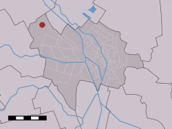
 Ockhuizen in the municipality of Utrecht. | |
| Coordinates: 52°07′43″N 4°59′50″E / 52.12861°N 4.99722°E | |
| Country | Netherlands |
| Province | Utrecht |
| Municipality | Utrecht |
| Time zone | UTC+1 (CET) |
| • Summer (DST) | UTC+2 (CEST) |
Ockhuizen is a hamlet near the village of Haarzuilens in the Dutch province of Utrecht. It is a part of the municipality of Utrecht, and lies about 11 km northwest from the city centre of Utrecht.[1]
The hamlet has about 10 farmhouses and other dwellings.
References
[edit]- ^ ANWB Topografische Atlas Nederland, Topografische Dienst and ANWB, 2005.
External links
[edit]![]() Media related to Ockhuizen at Wikimedia Commons
Media related to Ockhuizen at Wikimedia Commons
