Centrale Region, Togo
Centrale | |
|---|---|
 Centrale Region of Togo | |
| Country | |
| Capital | Sokodé |
| Area | |
| • Total | 13,317 km2 (5,142 sq mi) |
| Population (2010 census) | |
| • Total | 617,871 |
| • Density | 46/km2 (120/sq mi) |
| HDI (2017) | 0.489[1] low · 3rd |
Centrale Region (French: Région Centrale) is one of Togo's five regions. Sokodé is the regional capital. Centrale is the least populated region in Togo with a total of 617,871 people according to a census done in 2010.[2]
Other major cities in the Centrale region include Tchamba and Sotouboua.


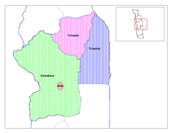
Centrale is divided into the prefectures of Blitta, Subprefecture Mö,[3] Sotouboua, Tchamba, and Tchaoudjo.
Centrale is located north of Plateaux Region and south of Kara Region. Like the rest of the regions of Togo, it borders Ghana in the west and Benin in the east — specifically the Northern Region in the northwest and the Volta Region in the southwest, and the Donga Department in the northeast and the Collines Department in the southeast.
See also
References
- ^ "Sub-national HDI - Area Database - Global Data Lab". hdi.globaldatalab.org. Retrieved 2018-09-13.
- ^ Law, Gwillim. "Regions of Togo". Statoids.com. Gwillim Law. Retrieved 11 April 2013.
- ^ "Annuaire Statistique du Togo (2010-2013)" (in French). October 2019. Archived from the original on 2021-05-26. Retrieved 2021-08-06.
8°36′N 1°06′E / 8.600°N 1.100°E
