Toshkan River
| Toshkan | |
|---|---|
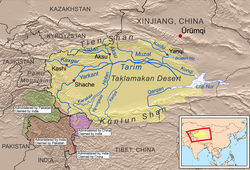
 Map showing the rivers of the Tarim Basin | |
 | |
| Location | |
| Country | Kyrgyzstan, China |
| Physical characteristics | |
| Mouth | Aksu |
• coordinates | 41°11′15″N 80°05′35″E / 41.1874°N 80.0931°E |
| Basin features | |
| Progression | Aksu→ Tarim→ Taitema Lake |
The Toshkan (Template:Lang-ug, Template:Lang-ky) is a river in the Tien Shan mountains in the border area between China and Kyrgyzstan. It is 345 kilometres (214 mi) long, and has a drainage basin of 8,270 square kilometres (3,190 sq mi) in Kyrgyzstan. The Toshkan has its sources in the At-Bashy Range and Kakshaal Too south of the Kyrgyzstani city of Naryn. In its uppermost course, upstream of the confluences with the rivers Müdürum and Kökkyya, it is called Aksay; from these confluences to the border with China, it is called Kakshaal.[1] It then flows towards the east and into the Xinjiang province of China. It continues east, running parallel to the Tien Shan mountains, until its confluence with the Aksu River near the city Aksu. The Toshkan is the largest tributary of the Aksu.
References
- ^ "Какшаал" [Kakshaal] (PDF). Кыргызстандын Географиясы [Geography of Kyrgyzstan] (in Kyrgyz). Bishkek. 2004. p. 189.
{{cite encyclopedia}}: CS1 maint: location missing publisher (link)
