Rae Parish
Rae Parish
Rae vald | |
|---|---|
 Jüri church | |
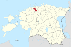
 Rae Parish within Harju County. | |
| Country | |
| County | |
| Administrative centre | Jüri |
| Government | |
| • Mayor | Madis Sarik |
| Area | |
• Total | 206.7 km2 (79.8 sq mi) |
| Population (31.12.2022) | |
• Total | 23,145 |
| • Density | 110/km2 (290/sq mi) |
| ISO 3166 code | EE-653 |
| Website | www.rae.ee |
Rae Parish (Template:Lang-et) is a rural municipality in northern Estonia. It is a part of Harju County. The municipality has a population of 23,145 (as of 31 December 2022)[1] and covers an area of 206.7 km².[2] The population density is 111.974/km2 (290.01/sq mi).
Settlements
Administrative centre of the municipality is Jüri, a small borough. The other biggest populated places are Vaida, Assaku, Lagedi and Peetri small boroughs. The rest of the settlements are villages: Aaviku, Aruvalla, Järveküla, Kadaka, Karla, Kautjala, Kopli, Kurna, Lehmja, Limu, Pajupea, Patika, Pildiküla, Rae, Salu, Seli, Soodevahe, Suuresta, Suursoo, Tuulevälja, Ülejõe, Urvaste, Uuesalu, Vaidasoo, Vaskjala, Veneküla and Veskitaguse. There are altogether 5 small boroughs plus 27 villages & hamlets in Rae Parish.
The current mayor (vallavanem) is Madis Sarik (Estonian Reform Party).[3]
Religion
Religion in Rae Parish (2021) [1]
References
- ^ "Rahvastik" (in Estonian). Rae vald. Retrieved 1 June 2023.
- ^ "Tutvustus" (in Estonian). Rae vald. Retrieved 11 January 2010.
- ^ "Vallavalitsuse kontaktid" (in Estonian). Rae vald. Retrieved 16 December 2019.
External links
- Official website (available only in Estonian)
59°23′08″N 24°52′59″E / 59.38556°N 24.88306°E


