Fidar
Appearance
Fidar
فدار | |
|---|---|
| Coordinates: 34°8′1″N 35°41′8″E / 34.13361°N 35.68556°E | |
| Country | Lebanon |
| Governorate | Keserwan-Jbeil |
| District | Byblos |
| Area | |
• Total | 390 ha (960 acres) |
| Elevation | 920 m (3,020 ft) |
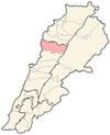
Fidar (Template:Lang-ar), municipality in the Byblos District of Keserwan-Jbeil Governorate, Lebanon. It is 35 kilometers of Beirut. Fidar has an average elevation of 100 meters above sea level and a total land area of 390 hectares. As of 2008, the village contained one public school with 206 students enrolled.[1][2] Nassib Zgheib is the president of the municipality since 2019. This small village is also known for his 800-year-old church (kniset saïdet el doueir).[citation needed]
References
- ^ "Bichtlida - Fdar". Localiban. Localiban. 2021-09-11. Archived from the original on 2018-06-27. Retrieved 2021-09-11.
- ^ "Districts in Depth: Jbeil". NOW News. 2009-05-28. Retrieved 2016-02-12.


