Petrohrad
Appearance
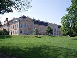
Petrohrad | |
|---|---|
 Petrohrad Castle | |
| Coordinates: 50°7′39″N 13°26′47″E / 50.12750°N 13.44639°E | |
| Country | |
| Region | Ústí nad Labem |
| District | Louny |
| First mentioned | 1360 |
| Area | |
• Total | 18.50 km2 (7.14 sq mi) |
| Elevation | 365 m (1,198 ft) |
| Population (2023-01-01)[1] | |
• Total | 635 |
| • Density | 34/km2 (89/sq mi) |
| Time zone | UTC+1 (CET) |
| • Summer (DST) | UTC+2 (CEST) |
| Postal codes | 439 85, 441 01 |
| Website | www |
Petrohrad (Template:Lang-de) is a municipality and village in Louny District in the Ústí nad Labem Region of the Czech Republic. It has about 600 inhabitants.
Petrohrad lies approximately 36 kilometres (22 mi) south-west of Louny, 73 km (45 mi) south-west of Ústí nad Labem, and 71 km (44 mi) west of Prague.
Administrative parts
Villages of Bílenec and Černčice are administrative parts of Petrohrad.
References
Wikimedia Commons has media related to Petrohrad.


