Kampinos
Appearance
Kampinos | |
|---|---|
Village | |
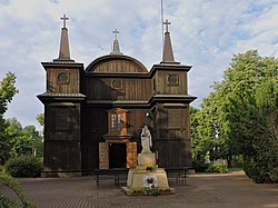
 Church of the Assumption | |
| Coordinates: 52°16′N 20°27′E / 52.267°N 20.450°E | |
| Country | |
| Voivodeship | Masovian |
| County | Warsaw West |
| Gmina | Kampinos |
| Website | http://www.kampinos.pl/ |
Kampinos [kamˈpinɔs] is a village in Warsaw West County, Masovian Voivodeship, in east-central Poland. It is the seat of the gmina (administrative district) called Gmina Kampinos.[1] It lies approximately 8 kilometres (5 mi) east of Sochaczew and 38 km (24 mi) west of Warsaw.
The village lies on the southern edge of the Kampinos Forest, which is protected as a national park (Kampinos National Park) and has been designated a biosphere reserve by UNESCO.
References
External links
- Jewish Community in Kampinos on Virtual Shtetl


