Yeongyang County
This article relies largely or entirely on a single source. (May 2018) |
Yeongyang
영양군 | |
|---|---|
| Korean transcription(s) | |
| • Hangul | 영양군 |
| • Hanja | 英陽郡 |
| • Revised Romanization | Yeongyang-gun |
| • McCune-Reischauer | Yŏngyang-gun |
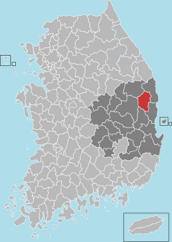
 Location in South Korea | |
| Country | |
| Region | Yeongnam |
| Administrative divisions | 1 eup, 5 myeon |
| Area | |
| • Total | 815.14 km2 (314.73 sq mi) |
| Population | |
| • Total | 17,829 (2,016.2.29) |
| • Density | 21.8/km2 (56/sq mi) |
| • Dialect | Gyeongsang |
Yeongyang County (Yeongyang-gun) is an inland county in the north-eastern area of North Gyeongsang Province, South Korea.
Geography
An isolated area difficult to access, Yeongyang is sometimes called an "inland island". The county has the lowest population of all counties in North Gyeongsang Province (without Ulleung County), being mountainous with deep ravines, and only 10 percent of land is cultivable.
Climate
Yeongyang has a humid continental climate (Köppen: Dwa), but can be considered a borderline humid subtropical climate (Köppen: Cwa) using the −3 °C (27 °F) isotherm.
| Climate data for Yeongyang (1993–2020 normals) | |||||||||||||
|---|---|---|---|---|---|---|---|---|---|---|---|---|---|
| Month | Jan | Feb | Mar | Apr | May | Jun | Jul | Aug | Sep | Oct | Nov | Dec | Year |
| Mean daily maximum °C (°F) | 4.0 (39.2) |
6.9 (44.4) |
12.1 (53.8) |
18.3 (64.9) |
23.6 (74.5) |
26.6 (79.9) |
28.3 (82.9) |
28.9 (84.0) |
24.7 (76.5) |
19.9 (67.8) |
12.9 (55.2) |
6.0 (42.8) |
17.7 (63.9) |
| Daily mean °C (°F) | −2.5 (27.5) |
0.1 (32.2) |
5.1 (41.2) |
11.2 (52.2) |
16.3 (61.3) |
20.0 (68.0) |
23.3 (73.9) |
23.8 (74.8) |
18.7 (65.7) |
12.6 (54.7) |
6.0 (42.8) |
−0.5 (31.1) |
11.2 (52.2) |
| Mean daily minimum °C (°F) | −8.5 (16.7) |
−6.2 (20.8) |
−1.5 (29.3) |
3.8 (38.8) |
9.5 (49.1) |
14.5 (58.1) |
19.5 (67.1) |
19.8 (67.6) |
14.4 (57.9) |
7.2 (45.0) |
0.1 (32.2) |
−6.1 (21.0) |
5.5 (41.9) |
| Average precipitation mm (inches) | 19.4 (0.76) |
22.8 (0.90) |
42.2 (1.66) |
75.2 (2.96) |
78.3 (3.08) |
114.5 (4.51) |
209.2 (8.24) |
208.9 (8.22) |
128.4 (5.06) |
50.4 (1.98) |
30.6 (1.20) |
16.8 (0.66) |
996.7 (39.24) |
| Average precipitation days (≥ 0.1 mm) | 3.2 | 3.5 | 6.2 | 7.0 | 7.4 | 8.2 | 11.2 | 11.6 | 9.0 | 4.7 | 5.1 | 3.2 | 80.3 |
| Source: Korea Meteorological Administration[1] | |||||||||||||
Local specialties
The county is famous for its apples and chili peppers, and is home to the Yeongyang Chili Pepper Experimental Station. From 1984, the county has elected a "Miss Chili Pepper" to represent Yeongyang chili peppers.
Culture
The area is known as a centre of literature, with the tradition of scholars reading and reciting poetry deep in the mountains, from which have emerged Oh Il-do, Cho Chi-hun and Yi Munyol. Within the county, the Yeondaeam historic temple is located in the village of Samji-Ri.
Administrative divisions

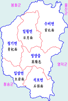
Yeongyang County is divided into 1 eup and 5 myeon.
| Name | Hangeul | Hanguk |
|---|---|---|
| Yeongyang-eup | 영양읍 | 英陽邑 |
| Ibam-myeon | 입암면 | 立岩面 |
| Cheonggi-myeon | 청기면 | 靑杞面 |
| Irwol-myeon | 일월면 | 日月面 |
| Subi-myeon | 수비면 | 首比面 |
| Seokbo-myeon | 석보면 | 石保面 |
Twin towns – sister cities
Yeongyang is twinned with:
References
- ^ "Climatological Normals of Korea (1991 ~ 2020)" (PDF) (in Korean). Korea Meteorological Administration. Archived from the original (PDF) on 29 January 2022. Retrieved 7 June 2023.
External links
36°40′0″N 129°06′44″E / 36.66667°N 129.11222°E


