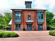
Xenia Station

Xenia Station, located at 150 Miami Avenue in Xenia, Ohio, in the United States, is a replica of Xenia's 1880s brick railroad station.
Built in 1998 by the city of Xenia, Xenia Station houses a local history museum, a classroom/meeting space and an observation tower called the Hub Lookout.
Xenia Station is the hub for 5 regional rail trails, two of which are segments of the unfinished Ohio to Erie Trail, which will run from Cincinnati to Cleveland.[1][2]
Facilities
[edit]Xenia Station was designed by Schooley Caldwell Architects in 1998 and custom built for the city of Xenia by a local contractor[3] and is located on a 9-acre (36,000 m2) city park of the same name, which has play equipment, picnic tables, a picnic shelter, nature areas, a splash pad, a caboose and off-street parking. The site is the former PRR freight yards. The building's first floor houses a local history museum which includes railroad memorabilia while the second floor has a classroom/meeting space. Xenia Station is also the hub for 5 regional rail trails, two of which are segments of the unfinished Ohio to Erie Trail, which will run from Cincinnati to Cleveland. In addition to the museum and classroom/meeting space, the building also has restrooms, vending machines and water for the bicyclists, hikers and others who use the park. It also has a large map of the rail trails and the Hub Lookout, which is a tower accessible by spiral staircase that provides a panoramic view of the rail trails.[1][2]
Railroad history
[edit]As late as 1960, Xenia had three rail lines running through it, as follows:
- The Baltimore & Ohio Wellston subdivision, which ran between Washington Court House and Dayton;
- The Pennsylvania Railroad's (PRR) Little Miami branch, between Cincinnati and Springfield: and
- The PRR's Pittsburgh to St. Louis mainline. Amtrak utilized this line for the National Limited until 1979.
All three route saw diminished usage by the early 1980s: each was eventually abandoned and dismantled. PRR's Pittsburgh-St. Louis mainline, owned by Conrail after 1976, remained intact until the late 1980s.
Rail trails
[edit]The crossing of the three railroad lines created six spokes on a wheel with Xenia Station in the center. Of these six spokes, five have been converted for interim rail trail use.
The one exception was the B&O line west to Dayton which did not become a trail because it closely paralleled the PRR line to Dayton.[1]
Clockwise from the north, the five trails are:[1]
North
[edit]The northern branch of the Little Miami Scenic Trail runs from Xenia to Yellow Springs and on to Springfield. This is the former PRR line to Springfield.
Northeast
[edit]The Prairie Grass Trail (a part of the Ohio to Erie Trail) runs from Xenia to Cedarville and to London and beyond. Former PRR Pittsburgh-St. Louis mainline east to London and Columbus.
East
[edit]The Xenia-Jamestown Connector will run from Xenia to Jamestown and beyond, but there is now a short gap from Xenia Station to Jasper Road. Former B&O Wellston Subdivision to Chillicothe and Wellston.
South
[edit]The southern branch of the Little Miami Scenic Trail is a part of the Ohio to Erie Trail and runs from Xenia to Milford and beyond. Former PRR line to Cincinnati.
West
[edit]The Creekside Trail, known as the Creekside Recreation Trail in Montgomery County, runs from Xenia to Dayton. Former PRR Pittsburgh-St. Louis mainline to Dayton.
See also
[edit]References
[edit]- ^ a b c d Miami Valley Bike Trails - Xenia Station Archived April 18, 2008, at the Wayback Machine
- ^ a b City of Xenia site for Xenia Station
- ^ David Metthews
External links
[edit]- Miami Valley Bike Trails - Xenia Station
- David Matthews
- Greene County Parks and Trails: Stations and Staging Places on Greene Trails - includes Xenia Station
- Ohio Bikeways - Xenia Station
- Xenia Community Schools
- City of Xenia list of parks including Xenia Station
- City of Xenia gallery for Xenia Station
