Cananéia
Cananéia | |
|---|---|
| Municipality of Cananéia | |
 | |
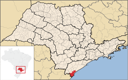
 Location in São Paulo | |
| Coordinates: 25°00′53″S 47°55′36″W / 25.01472°S 47.92667°W | |
| Country | |
| Region | Southeast |
| State | |
| Founded | 12 August 1531 |
| Government | |
| • Mayor | Gabriel Guimarães (GUIMA) (PV) |
| Area | |
| • Total | 1,242.010 km2 (479.543 sq mi) |
| Elevation | 8 m (26 ft) |
| Population (2020)[1] | |
| • Total | 12,541 |
| • Density | 11.4/km2 (30/sq mi) |
| Time zone | UTC−3 (BRT) |
| HDI (2010) | 0.720 – high[2] |
| Website | Official website |
Cananéia is the southernmost city in the state of São Paulo, Brazil, near where the Tordesilhas Line passed. The population in 2020 was 12,541 and its area is 1,242.010 km². The elevation is 8 m. The city of Cananéia is host to the Dr. João de Paiva Carvalho research base belonging to the Oceanographic Institute of the University of São Paulo.
History
Founded in 1531, Cananéia is considered by some to be the oldest city in Brazil (5 months before the foundation of São Vicente) but due to the lack of official documentation proving this fact, São Vicente is officially the oldest city in Brazil. The historic center of Cananéia still preserves the architectural styles adopted by the first houses from the colonial period to the end of the 19th century.
Conservation
The municipality contains the 13,500 hectares (33,000 acres) Ilha do Cardoso State Park, created in 1962.[3] It contains part of the Tupiniquins Ecological Station.[4] It contains the 1,176 hectares (2,910 acres) Mandira Extractive Reserve, established in 2002.[5] The municipality contains the 1,662 hectares (4,110 acres) Taquari Extractive Reserve, created in 2008.[6] It contains the 1,128 hectares (2,790 acres) Ilha do Tumba Extractive Reserve, also created in 2008.[7] It contains the 1,243 hectares (3,070 acres) Itapanhapima Sustainable Development Reserve, created at the same time.[8]
References
- ^ IBGE 2020
- ^ "ranking-idhm-2010.pdf" (PDF). United Nations Development Programme (UNDP). Archived from the original (PDF) on July 8, 2014. Retrieved August 1, 2013.
- ^ Sobre o Parque (in Portuguese), SAP: Sistema Ambiental Paulista, archived from the original on 2016-09-30, retrieved 2016-11-17
- ^ Unidade de Conservação: Estação Ecológica dos Tupiniquins, MMA: Ministério do Meio Ambiente, retrieved 2016-04-18
- ^ RESEX do Mandira (in Portuguese), ISA: Instituto Socioambiental, retrieved 2016-09-19
- ^ RESEX Taquari (in Portuguese), ISA: Instituto Socioambiental, retrieved 2016-11-21
- ^ RESEX da Ilha do Tumba (in Portuguese), ISA: Instituto Socioambiental, retrieved 2016-11-25
- ^ RDS de Itapanhapima (in Portuguese), ISA: Instituto Socioambiental, retrieved 2016-11-25

