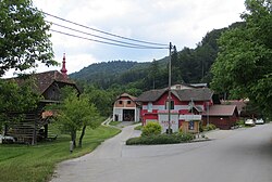
Ločica pri Vranskem
Ločica pri Vranskem | |
|---|---|
 | |
| Coordinates: 46°13′33.61″N 14°56′45.86″E / 46.2260028°N 14.9460722°E | |
| Country | |
| Traditional region | Styria |
| Statistical region | Savinja |
| Municipality | Vransko |
| Area | |
• Total | 7 km2 (3 sq mi) |
| Elevation | 365.4 m (1,198.8 ft) |
| Population (2002) | |
• Total | 151 |
| [1] | |
Ločica pri Vranskem (pronounced [lɔˈtʃiːtsa pɾi ˈwɾaːnskɛm]) is a settlement in the Municipality of Vransko in central Slovenia. It lies at the crossroads of the regional roads leading to Kamnik, Celje, and Ljubljana in the valley of Bolska Creek, a right tributary of the Savinja River. The Slovenian A1 motorway passes just east of the village core. The area is part of the traditional region of Styria. The municipality is now included in the Savinja Statistical Region.[2] It includes the hamlets of Bistrica, Brce, Jakov Dol, and Osredek.
Name
The name of the settlement was changed from Ločica to Ločica pri Vranskem in 1953.[3]
Church

The local church is dedicated to Mary Magdalene and belongs to the Parish of Vransko. It dates to the 16th century with some later rebuilding and extensions.[4]
Gallery
-
Historical postcard of Ločica pri Vranskem
-
The hamlet of Bistrica
References
- ^ Statistical Office of the Republic of Slovenia
- ^ Vransko municipal site
- ^ Spremembe naselij 1948–95. 1996. Database. Ljubljana: Geografski inštitut ZRC SAZU, DZS.
- ^ Slovenian Ministry of Culture register of national heritage reference number ešd 3508
External links
 Media related to Ločica pri Vranskem at Wikimedia Commons
- Ločica pri Vranskem on Geopedia


