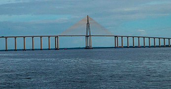
Rio Negro Bridge
You can help expand this article with text translated from the corresponding article in Portuguese. (January 2021) Click [show] for important translation instructions.
|
You can help expand this article with text translated from the corresponding article in German. (January 2021) Click [show] for important translation instructions.
|
Rio Negro Bridge | |
|---|---|
 Rio Negro Bridge, 2019. | |
| Coordinates | 3°7′19″S 60°04′46″W / 3.12194°S 60.07944°W |
| Carries | 4 lanes of roadway |
| Crosses | Rio Negro |
| Locale | Manaus and Iranduba, Amazonas, Brazil |
| Official name | Journalist Phelippe Daou Bridge |
| Characteristics | |
| Design | Cable-stayed bridge |
| Total length | 3,595 metres (11,795 ft) |
| Height | 185 metres (607 ft)[1] |
| Longest span | 2x200 metres (660 ft) |
| Clearance above | 55 metres (180 ft)[1] |
| History | |
| Construction start | December 3, 2007 |
| Opened | October 24, 2011 |
| Location | |
 | |
The Journalist Phelippe Dahsou Bridge (Template:Lang-pt) is the fourth longest bridge[2] in Brazil at 3,595-metre (11,795 ft) long with a cable-stayed bridge section of 400-metre (1,132 ft)[2] over the Rio Negro that links the cities of Manaus and Iranduba in the state of Amazonas in Brazil.[3] It spans the Rio Negro just before its confluence with the Amazon River, and is the only major bridge across the Amazon or any tributary in the Amazon basin.[3] Its construction was marked by controversy over the potential effects of roadbuilding in the Amazon basin, which could lead to deforestation.[4] A 2018 study found that the construction of this bridge did induce deforestation.[5]
Though it does not directly connect to the south side of the Amazon River, its construction has raised the possibility of expansion and reconstruction of the federal highway BR-319, which links the region to Porto Velho, Rondônia, and thus to the rest of Brazil.[4] That road is on the south side of the Amazon, and so any vehicle from Manaus would still have to make a ferry connection across the main stem of the Amazon, despite the completion of the Rio Negro bridge.
-
185 meter high central mast
-
Bridge at dusk
-
Inauguration of the bridge
-
Rio Negro Bridge at night
References
- ^ a b "Governo do Amazonas inaugura ponte Rio Negro, um marco para a integração da Região Metropolitana de Manaus". Governo do Estado do Amazonas. Retrieved 2019-10-30.
- ^ a b "Rio Negro Bridge, $400-Million Economic Link, Opens in Amazon Basin". www.enr.com. Retrieved 2021-12-07.
- ^ a b "First Amazon bridge to open world's greatest rainforest to development". The Guardian. 2010-08-05. Retrieved 2019-10-30.
- ^ a b "Rio Negro Bridge, $400-Million Economic Link, Opens in Amazon Basin". www.enr.com. Retrieved 2021-01-31.
- ^ Ramos, Camila Julia Pacheco; de Alencastro Graça, Paulo Maurício Lima; Fearnside, Philip Martin (2018-12-01). "Deforestation Dynamics on an Amazonian Peri-Urban Frontier: Simulating the Influence of the Rio Negro Bridge in Manaus, Brazil". Environmental Management. 62 (6): 1134–1149. doi:10.1007/s00267-018-1097-3. ISSN 1432-1009. PMID 30171329. S2CID 52141121.
External links
- Secretaria de Estado de Infraestrutura - SEINFRA (Infrastructure Site of the State of Amazonas)
3°7′19″S 60°04′46″W / 3.12194°S 60.07944°W


