Pardo Ridge
Appearance

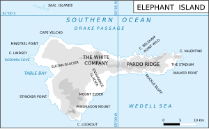
Pardo Ridge is the second highest part of Elephant Island, South Shetland Islands, reaching an altitude of 853 meters.[1] It extends from The White Company in the west to Cape Valentine in the east.[2] It was mapped by the UK Joint Services Expedition, 1970-71, and named by the UK-APC after Captain Luis Pardo, commander of the Chilean tug Yelcho which rescued shipwrecked members of Shackleton's Endurance from Elephant Island's Wild Point in August 1916.[2][3]
See also
[edit]References
[edit]- ^ Hodgson, Dominic A.; Graham, Alastair G.C. (2014). "Terrestrial and submarine evidence for the extent and timing of the Last Glacial Maximum and the onset of deglaciation on the maritime Antarctic and sub-Antarctic islands". Quaternary Science Reviews. 100: 142–3 – via Digital Commons @ University of South Florida.
- ^ a b "Gazetteer - AADC". data.aad.gov.au. Retrieved 13 February 2023.
- ^ "201610 by Navy News - Issuu". issuu.com. Retrieved 13 February 2023.
61°07′30″S 54°53′00″W / 61.12500°S 54.88333°W
