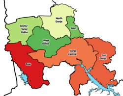
North Gonja (district)
Appearance
North Gonja District | |
|---|---|
 Districts of Savannah Region | |
Location of North Gonja District within Savannah | |
| Coordinates: 9°31′49″N 1°22′56″W / 9.53028°N 1.38222°W | |
| Country | |
| Region | Savannah |
| Capital | Daboya |
| Population (2010) | |
• Total | 43,547 |
| Time zone | UTC+0 (GMT) |
| ISO 3166 code | GH-SA-NG |
North Gonja District is one of the seven districts in Savannah Region, Ghana.[1][2][3] Originally it was formerly part of the then-larger West Gonja District on 23 December 1988, until the northern part of the district was split off on 28 June 2012 to create North Gonja District; thus the remaining part has been retained as West Gonja Municipal District (which it was elevated to municipal district assembly status on 27 January 2020). The district assembly is located in the central part of Savannah Region and has Daboya as its capital town. In 2023, the District Chief Executive is Adam Illiasu.[4]
Population
[edit]As of the 2010 Ghanaian census, the population was 43,547.[5]
See also
[edit]- "Districts of Ghana". Statoids.
References
[edit]- ^ "New Districts & Nominated DCEs" (PDF). ghanadistricts. Archived from the original (PDF) on 5 March 2013.
- ^ "All Districts". ghanadistricts. Retrieved 8 June 2018.
- ^ "Districts of Ghana". statoids. Retrieved 8 June 2018.
- ^ Online, Peace FM. "Renewed Clashes At Lukula, Mempeasem, 100 Arrested". Peacefmonline.com - Ghana news. Retrieved 2023-07-15.
- ^ Nyarko, Philomena (2014). "2010 Population and Housing Census - District Analytical Report" (PDF). Stats Ghana.

