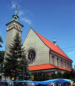
Pogrzebień
Appearance
Pogrzebień | |
|---|---|
Village | |
 Church of Saint Bartholomew | |
| Coordinates: 50°4′N 18°18′E / 50.067°N 18.300°E | |
| Country | |
| Voivodeship | Silesian |
| County | Racibórz |
| Gmina | Kornowac |
| Population | |
| • Total | 1,100 |
Pogrzebień [pɔˈɡʐɛbjɛɲ] is a village in the administrative district of Gmina Kornowac, within Racibórz County, Silesian Voivodeship, in southern Poland.[1] It lies approximately 2 kilometres (1 mi) south-west of Kornowac, 6 km (4 mi) east of Racibórz, and 54 km (34 mi) west of the regional capital Katowice.
References
Further reading
- Nouveau traité de géographie, Volume 6, Nouveau traité de géographie, Anton Friedrich Büsching, Anton Friedrich Büsching, P. Gosse jr. D. Pinet, 1772
- Archiv für slavische Philologie, Volume 20, Veröffentlichungen des Instituts für Slawistik, Weidmann., 1812-1898
- Wisła: miesięcznik geograficzno-etnograficzny, (Vol. 19), M. Arcta., 1905
- Rozprawy, Volumes 1–3, Wydawnictwa Łódzkiego Towarzystwa Naukowego - Łódzkie Towarzystwo Naukowe, Zakład im. Ossolinskich, 1954
- Погребной (in Russian)


