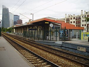
Courbevoie station
Appearance
 | |||||||||||
| General information | |||||||||||
| Location | Courbevoie, Hauts-de-Seine, Île-de-France | ||||||||||
| Coordinates | 48°53′54″N 2°14′55″E / 48.89833°N 2.24861°E | ||||||||||
| Line(s) | |||||||||||
| Platforms | 2 side platforms | ||||||||||
| Tracks | 2 | ||||||||||
| Other information | |||||||||||
| Station code | 87382200 | ||||||||||
| Fare zone | 3 | ||||||||||
| History | |||||||||||
| Opened | 1838 | ||||||||||
| Services | |||||||||||
| |||||||||||
Courbevoie is a railway station serving the town Courbevoie, Hauts-de-Seine department, in the western suburbs of Paris, France. It is served by Transilien Line L services between Paris Gare Saint-Lazare and Gare de Saint-Cloud.
External links
Wikimedia Commons has media related to Gare de Courbevoie.
- Courbevoie station at Transilien, the official website of SNCF (in French)
