Jump to content

GR 58

Coordinates: 44°40′52″N 6°58′04″E / 44.6812°N 6.9678°E / 44.6812; 6.9678
From Wikipedia, the free encyclopedia

This is the current revision of this page, as edited by Bearcat (talk | contribs) at 21:26, 10 October 2023 (References). The present address (URL) is a permanent link to this version.

(diff) ← Previous revision | Latest revision (diff) | Newer revision → (diff)
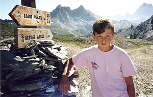
On the GR38 in 1989
On the GR38 in 1989

The GR 58, also: Tour du Queyras, is a long-distance walking route of the Grande Randonnée network in France. It forms a 108 km long loop in the Queyras, one of France's regional parks, in the department of the Hautes-Alpes. It passes through Ceillac, Saint-Véran, Abriès, Les Fonds and Brunissard.[1]

References

[edit]
  1. ^ GR-infos, GR 58

44°40′52″N 6°58′04″E / 44.6812°N 6.9678°E / 44.6812; 6.9678