Jump to content

Korona Peak

Coordinates: 42°30′24″N 74°34′1″E / 42.50667°N 74.56694°E / 42.50667; 74.56694
From Wikipedia, the free encyclopedia

This is an old revision of this page, as edited by Chongkian (talk | contribs) at 17:44, 30 October 2023 (stub template should be placed at the very end of article after external link, navbox & category tags per WP:STUBSPACING). The present address (URL) is a permanent link to this revision, which may differ significantly from the current revision.

Korona Peak
Pik Korona
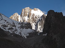
Korona Peak viewed from Ratcek Hut to the northwest
Highest point
Elevation4,860 m (15,940 ft)
Coordinates42°30′24″N 74°34′1″E / 42.50667°N 74.56694°E / 42.50667; 74.56694
Geography
Korona Peak is located in Kyrgyzstan
Korona Peak
Korona Peak
Parent rangeKyrgyz Ala-Too Range, Tian Shan

Korona Peak (Template:Lang-ru) is a mountain in the Kyrgyz Ala-Too Range of the Tian Shan. It is located in Ala Archa National Park in Kyrgyzstan.[1] It is named for its crown-like appearance.

Ak-Sai Glacier lies on its southwest flank.

References

  1. ^ "Ak-Sai Travel – Silk Road tours, Mountaineering: Lenin peak, Khan Tengri peak, Pobeda peak, trekking, fixed departure dates".