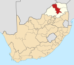
Moria, South Africa
Appearance
This article relies largely or entirely on a single source. (February 2023) |
Moria | |
|---|---|
 | |
| Coordinates: 23°56′17″S 29°47′28″E / 23.938°S 29.791°E | |
| Country | South Africa |
| Province | Limpopo |
| District | Capricorn |
| Municipality | Polokwane |
| Main Place | GaMokwane |
| Area | |
• Total | 5.06 km2 (1.95 sq mi) |
| Population (2011)[1] | |
• Total | 2,887 |
| • Density | 570/km2 (1,500/sq mi) |
| Racial makeup (2011) | |
| • Black African | 99.7% |
| • Coloured | 0.2% |
| • Indian/Asian | 0.0% |
| • White | 0.1% |
| First languages (2011) | |
| • Northern Sotho | 75.3% |
| • Tswana | 6.4% |
| • Tsonga | 3.4% |
| • Zulu | 3.3% |
| • Other | 11.6% |
| Time zone | UTC+2 (SAST) |
Moria is a town in Capricorn District Municipality in the Limpopo province of South Africa.
References
- ^ a b c d "Sub Place Moria". Census 2011.


