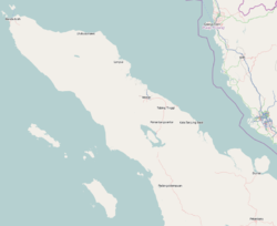
Salak, North Sumatra
Appearance
Salak, North Sumatra | |
|---|---|
Town | |
| Coordinates: 2°33′16.7″N 98°19′25.4″E / 2.554639°N 98.323722°E | |
| Country | |
| Province | |
| Regency | Pakpak Bharat |
| Area | |
• Total | 245.57 km2 (94.82 sq mi) |
| Elevation | 922 m (3,025 ft) |
| Population (2020 Census)[1] | |
• Total | 10,057 |
| • Density | 41/km2 (110/sq mi) |
| Time zone | UTC+7 (Western Indonesian Time) |
| Area code | +62627 |
Salak is a town and district in North Sumatra province of Indonesia, the capital of Pakpak Bharat Regency.
Climate
Salak has an elevation moderated tropical rainforest climate (Af) with heavy rainfall year-round.
| Climate data for Salak | |||||||||||||
|---|---|---|---|---|---|---|---|---|---|---|---|---|---|
| Month | Jan | Feb | Mar | Apr | May | Jun | Jul | Aug | Sep | Oct | Nov | Dec | Year |
| Mean daily maximum °C (°F) | 27.0 (80.6) |
27.5 (81.5) |
27.5 (81.5) |
27.5 (81.5) |
27.7 (81.9) |
27.5 (81.5) |
27.2 (81.0) |
27.0 (80.6) |
26.5 (79.7) |
26.2 (79.2) |
26.1 (79.0) |
26.5 (79.7) |
27.0 (80.6) |
| Daily mean °C (°F) | 21.9 (71.4) |
22.1 (71.8) |
22.2 (72.0) |
22.4 (72.3) |
22.5 (72.5) |
22.1 (71.8) |
21.9 (71.4) |
21.8 (71.2) |
21.7 (71.1) |
21.7 (71.1) |
21.6 (70.9) |
21.8 (71.2) |
22.0 (71.6) |
| Mean daily minimum °C (°F) | 16.8 (62.2) |
16.7 (62.1) |
17.0 (62.6) |
17.4 (63.3) |
17.4 (63.3) |
16.8 (62.2) |
16.6 (61.9) |
16.6 (61.9) |
16.9 (62.4) |
17.3 (63.1) |
17.2 (63.0) |
17.1 (62.8) |
17.0 (62.6) |
| Average rainfall mm (inches) | 229 (9.0) |
183 (7.2) |
254 (10.0) |
281 (11.1) |
199 (7.8) |
127 (5.0) |
108 (4.3) |
156 (6.1) |
220 (8.7) |
302 (11.9) |
307 (12.1) |
280 (11.0) |
2,646 (104.2) |
| Source: Climate-Data.org[2] | |||||||||||||
References
- ^ Badan Pusat Statistik, Jakarta, 2021.
- ^ "Climate: Salak". Climate-Data.org. Retrieved 6 November 2020.

