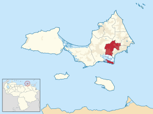
García Municipality
Appearance
García Municipality
Municipio García | |
|---|---|
 Location in Nueva Esparta | |
| Coordinates: 10°56′42″N 63°54′16″W / 10.945°N 63.9044°W | |
| Country | |
| State | Nueva Esparta |
| Municipal seat | El Valle del Espíritu Santo |
| Area | |
| • Total | 79.6 km2 (30.7 sq mi) |
| Time zone | UTC−4 (VET) |
| Website | garcia-nuevaesparta |
García,[1] officially José María García is a municipality located in the eastern part of Margarita Island, bordered by the Caribbean Sea and with the municipalities of Arismendi, Mariño and Díaz, in Venezuela. The municipal capital is El Valle del Espíritu Santo.
References
- ^ "Wayback Machine" (PDF). web.archive.org. Retrieved 2023-12-31.


