Jump to content

Rapples Pan

Coordinates: 26°49′50″S 20°48′55″E / 26.83056°S 20.81528°E / -26.83056; 20.81528
From Wikipedia, the free encyclopedia

This is an old revision of this page, as edited by Yobot (talk | contribs) at 09:05, 7 November 2013 (References: WP:CHECKWIKI error fixes using AWB (9585)). The present address (URL) is a permanent link to this revision, which may differ significantly from the current revision.

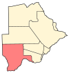
Rapples Pan is located in Botswana
Rapples Pan
Location of Rapples Pan

Rapples Pan is a village in Kgalagadi District of Botswana. It is located at the south-western tip of Botswana, close to the South African border. It has a primary school, and the population was recorded as 283 by the 2011 census.[1]

References

  1. ^ "2011 Botswana Population and Housing Census" (PDF). Retrieved 2013-09-11.

26°49′50″S 20°48′55″E / 26.83056°S 20.81528°E / -26.83056; 20.81528