
Werkhoven
Werkhoven | |
|---|---|
Town | |
 Windmill near Werkhoven | |
 Coat of arms | |
 | |
 The village (dark green) and statistical district (light green) of Werkhoven in the municipality of Bunnik. | |
| Coordinates: 52°1′26″N 5°14′35″E / 52.02389°N 5.24306°E | |
| Country | Netherlands |
| Province | Utrecht |
| Municipality | Bunnik |
| Population (2001) | |
| • Total | 1,528 |
| Time zone | UTC+1 (CET) |
| • Summer (DST) | UTC+2 (CEST) |
| Postal code | 3985 |
| Dialing code | 0343 |
Werkhoven is a town in the Dutch province of Utrecht. It is a part of the municipality of Bunnik, and lies about 5 km east of Houten.
In 2001, the town of Werkhoven had 1528 inhabitants. The built-up area of the town was 0.29 km², and contained 550 residences.[1] The neighbourhood of Werkhoven, which covers the entire area of the former municipality, has about 2320 inhabitants.[2]
Werkhoven used to be a separate municipality. It merged with Bunnik and Odijk in 1964.
Born in Werkhoven
- Coby van Baalen (*1957), Dutch equestrian.
- Andreas Everardus van Braam Houckgeest (1739–1801), Dutch merchant and diplomat.
- John Oostrom, (born September 2, 1930), a former business executive and Canadian parliamentarian. He was the first Dutch-born Canadian elected to the Canadian House of Commons
Pictures
-
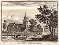 Werkhoven in an engraving by Hendrik Spilman, 1773
 -
 kasteel Beverweerd
 -
 Dorpskerk
 -
 De Brink
 -
 Werkhoven ca. 1865
 -
 Skyline Werkhoven, 2008
 -
 Watertower


References
External links
Wikimedia Commons has media related to Bunnik#Werkhoven.
- Template:Kuypers Map of the former municipality in 1868.