Chwałęcice
Appearance
Chwałęcice | |
|---|---|
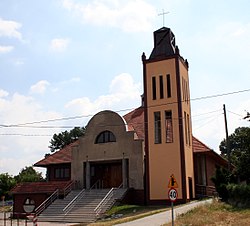
 Local Catholic church | |
 Location of Chwałęcice within Rybnik | |
| Coordinates: 50°08′11″N 18°28′49″E / 50.136515°N 18.480301°E | |
| Country | |
| Voivodeship | Silesian |
| County/City | Rybnik |
| Population (2013) | |
• Total | 1,800 |
| Time zone | UTC+1 (CET) |
| • Summer (DST) | UTC+2 (CEST) |
| Area code | (+48) 032 |
Chwałęcice (Template:Lang-de) is a district of Rybnik, Silesian Voivodeship, southern Poland. In late 2013 it had about 1,800 inhabitants.[1]
History
Chwałęcice probably existed already in the 12th century.
After World War I in the Upper Silesia plebiscite 233 out of 274 voters in Chwałęcice voted in favour of joining Poland, against 41 opting for staying in Germany.[2] In 1922 it became a part of Silesian Voivodeship, Second Polish Republic. It was then annexed by Nazi Germany at the beginning of World War II. After the war it was restored to Poland.
In the years 1973–1977 it was the seat of a gmina, which (Chwałęcice and Stodoły) was amalgamated with Rybnik on February 1, 1977.[3]
References
- ^ "Chwałęcice" (in Polish). rybnik.eu. Retrieved 2015-05-13.
- ^ "Results of the Upper Silesia plebiscite in Rybnik County" (in German). Retrieved 2015-05-03.
- ^ Rozporządzenie Ministra Administracji, Gospodarki Terenowej i Ochrony Środowiska z dnia 25 stycznia 1977 r. w sprawie zmiany granic niektórych miast w województwie katowickim., Dz. U., 1977, vol. 3, No. 15
