
Lernapar
40°44′55″N 44°09′38″E / 40.74861°N 44.16056°E
Lernapar
Լեռնապար | |
|---|---|
 Lernapar with Tsaghkasar Mountain (background) | |
 Lernapar | |
| Coordinates: 40°44′55″N 44°09′38″E / 40.74861°N 44.16056°E | |
| Country | Armenia |
| Marz (Province) | Aragatsotn |
| Population (2001) | |
| • Total | 534 |
| Time zone | UTC+4 ( ) |
| • Summer (DST) | UTC+5 ( ) |
Lernapar (Armenian: Լեռնապար; until 1978, Haykakan Pamb or Russified as Pamb Armyanskiy - both meaning "Armenian Pamb" as distinguished from Sipan, the Kurdish Pamb - and Gharakilisa - meaning "black church") is a small village in the Aragatsotn Province of Armenia.
Gallery
-
 Village chapel
 -
 Church ruins in the village
 -
 Church niche
 -
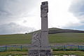 Memorial to the fallen World War II soldiers


See also
References
- Lernapar at GEOnet Names Server
- Report of the results of the 2001 Armenian Census, Statistical Committee of Armenia
- Kiesling, Rediscovering Armenia, p. 23, available online at the US embassy to Armenia's website

This article about a location in Aragatsotn Province, Armenia is a stub. You can help Wikipedia by expanding it. |