Dorkwerd
Dorkwerd | |
|---|---|
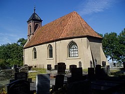
 Protestant Church | |
| Coordinates: 53°15′2″N 6°30′45″E / 53.25056°N 6.51250°E | |
| Country | Netherlands |
| Province | Groningen |
| Municipality | Groningen |
| Area | |
| • Total | 3.02 km2 (1.17 sq mi) |
| Population (2008) | 1,990 |
Dorkwerd is a small village in Groningen, the Netherlands. It is located in the municipality of Groningen, about 4 km northwest of the city center.[1] Recent construction of new residential areas have brought the city to less than 500 meters from the village of Dorkwerd.
Dorkwerd is one of the smallest villages of Groningen, consisting of a church and a few farms.
According to the 19th-century historian A.J. van der Aa,[2] Dorkwerd (also written Dorkwert, Dorquert) consisted of 19 houses, with a population of almost 140. Most of the village was in the municipality of Hoogkerk, west of the Reitdiep canal, but two houses belonging to the village were east of the canal in Adorp. There was a small village school here, built in 1832.
References
- ^ ANWB Topografische Atlas Nederland, Topografische Dienst and ANWB, 2005.
- ^ Abraham Jacob van der Aa, "Aardrijkskundig woordenboek der Nederlanden", vol. 3 (C/D), 1841.
External links
 Media related to Dorkwerd at Wikimedia Commons
53°15′00″N 6°30′45″E / 53.25000°N 6.51250°E

