Svitava (river)
Appearance
| Svitava | |
|---|---|
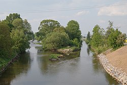
 Confluence of Svratka and Svitava (right) rivers | |
| Location | |
| Country | Czech Republic |
| Physical characteristics | |
| Mouth | |
• location | Svratka |
• coordinates | 49°08′32″N 16°37′42″E / 49.1421°N 16.6282°E |
| Length | 98.4 km (61.1 mi) |
| Basin size | 1,149 km2 (444 sq mi) |
| Basin features | |
| Progression | Svratka→ Thaya→ Morava→ Danube→ Black Sea |
The Svitava (German: Zwittawa) is a river in the Pardubice and South Moravian regions of the Czech Republic. The Svitava rises near Svitavy, passes through Blansko, and flows into the Svratka in the Moravian city of Brno. It is 98 kilometres (61 mi) long, and its basin area is 1,149 square kilometres (444 sq mi).[1]
References
- ^ "Charakteristiky toků a povodí ČR - Svitava" (in Czech). VÚV TGM. Retrieved 2018-05-08.
