Inferno Ridge
Appearance

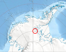
Inferno Ridge (79°26′S 84°13′W / 79.433°S 84.217°W) is a narrow ridge, 8 miles (13 km) long, rising between Schneider Glacier and Rennell Glacier in the Heritage Range, Antarctica. It was so named by the University of Minnesota Geological Party to these mountains, 1963–64, because the area is deeply dissected and composed of black rocks.[1]
Features
Geographical features include:
References
![]() This article incorporates public domain material from "Inferno Ridge". Geographic Names Information System. United States Geological Survey.
This article incorporates public domain material from "Inferno Ridge". Geographic Names Information System. United States Geological Survey.
