Warehouse District (Toledo, Ohio)


The Warehouse District in central Toledo, Ohio has seen a surprising upturn with new residential and entertainment developments alongside many in-use warehouses and warehouses that are in the process of being renovated.[1] The Warehouse District is immediately south of Downtown and is roughly bordered by Swan Creek, Monroe Street, Ontario Street, the Anthony Wayne Trail and I-75.[1]
Attractions

- 20 N Gallery (Art gallery)
- Erie Street Market
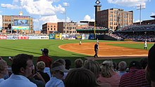
- Fifth Third Field (Mud Hens Baseball)
- Oliver House
- St. Patrick's Catholic Church
- Sur St. Clair (Art gallery)
- Toledo Art Walk
- Downtown Latte' Coffeehouse
- Blarney Irish Pub
- Pizza Papalis
- Frickers
- Packo's at the Park
- Ye Olde Cock 'n Bull Tavern
- Spaghetti Warehouse
- Ye Olde Durty Bird
- Bronze Boar
- The Retirement Group
- Martin Wood Appraisal
- NBS
- Paul Sullivan Architecture
- Gathered Glass Blowing Hotshop & Gallery
- Ahava Beauty Salon
- Bartley Lofts
- Standart Lofts
- Ottawa Condos
- Kengo Sushi & Yakitori
- M'Osteria and Bar
- Black Cloister Brewing Company
- Table Forty 4
