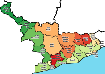
Upper Denkyira District
Appearance
Upper Denkyira District | |
|---|---|
Former District | |
 Location of Upper Denkyira District in Central Region | |
| Coordinates: 5°58′00″N 1°47′00″W / 5.9667°N 1.7833°W | |
| Region | Central Region |
| Area | |
| • Total | 1,139 km2 (440 sq mi) |
| Population | |
| • Ethnicity | Akan people |
The Upper Denkyira District is a former district that was located in the Central Region of Ashantiland Peninsula, Ghana. It was named after the former kingdom of Denkyira. The capital of Upper denkyira District was Dunkwa-On-Offin. The District Chief Executive was Richard Anane Adabor.[1]
External links
References
- ^ "Diaso chiefs root for Adabor's nomination as DCE". GhanaWeb. 26 February 2008. Retrieved 7 September 2010.


