
Altmärkische Höhe
Altmärkische Höhe | |
|---|---|
Location of Altmärkische Höhe within Stendal district 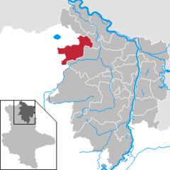 | |
 Altmärkische Höhe  Altmärkische Höhe | |
| Coordinates: 52°49′N 11°34′E / 52.817°N 11.567°E | |
| Country | Germany |
| State | Saxony-Anhalt |
| District | Stendal |
| Municipal assoc. | Seehausen |
| Government | |
| • Mayor | Bernd Prange |
| Area | |
| • Total | 98.91 km2 (38.19 sq mi) |
| Elevation | 32 m (105 ft) |
| Population (2022-12-31)[1] | |
| • Total | 1,813 |
| • Density | 18/km2 (47/sq mi) |
| Time zone | UTC+01:00 (CET) |
| • Summer (DST) | UTC+02:00 (CEST) |
| Postal codes | 39606, 39615 |
| Dialling codes | 039386, 039391, 039399 |
| Vehicle registration | SDL |
Altmärkische Höhe is a municipality in the district of Stendal, in Saxony-Anhalt, Germany.
It was formed on 1 January 2010 by the merger of the former municipalities Boock, Bretsch, Gagel, Heiligenfelde, Kossebau, Losse and Lückstedt.
References
- ^ "Bevölkerung der Gemeinden – Stand: 31. Dezember 2022" (PDF) (in German). Statistisches Landesamt Sachsen-Anhalt. June 2023.
Towns and municipalities in the district of Stendal | ||
|---|---|---|
 | ||
| International | |
|---|---|
| National | |
This Stendal district location article is a stub. You can help Wikipedia by expanding it. |