
Santa Rosa, Bolivia
Santa Rosa | |
|---|---|
| Santa Rosa | |
 Santa Rosa | |
| Coordinates: 17°53′06″S 64°17′54″W / 17.88500°S 64.29833°W | |
| Country | |
| Department | Santa Cruz |
| Time zone | UTC-4 (Bolivia Time) |
Santa Rosa is a remote rural village in the Department of Santa Cruz, Bolivia. It lies to the North of the Santa Cruz/Cochabamba highway and on the Southern border of the Amboro National Park.
Overview
It has one shop and a Roman Catholic church. None of the streets are paved. There are no mains services of any description. Communication with the outside world is by a solar powered radio transmitter. The access road is unpaved and subject to avalanche and flooding.
Photo gallery
The photo gallery gives a good idea of the typical rural village in the foothills of the Andes in Bolivia:
-
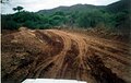 The access road to Santa Rosa.
 -
 The local Roman Catholic church. (Due for replacement).
 -
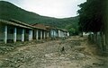 The Plaza, Santa Rosa.
 -
 None of the streets are paved in the village centre.
 -
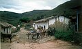 There is no mechanical transport inSanta Rosa.
 -
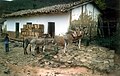 Donkeys deliver goods to the single shop in Santa Rosa.


