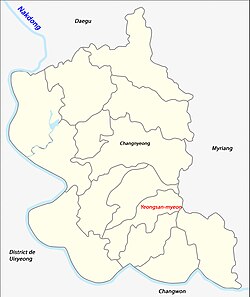
Yeongsan
Appearance
Yeongsan
영산 | |
|---|---|
| Korean transcription(s) | |
| • Hangul | 영산면 |
| • Hanja | 靈山面 |
| • Revised Romanization | Yeongsan-myeon |
| • McCune–Reischauer | Ryŏgsan-myŏn |
 Location in South Korea | |
| Coordinates: 35°27′15″N 128°31′31″E / 35.45417°N 128.52528°E | |
| Country | |
| Region | South Gyeongsang Province |
| Area | |
• Total | 29.36 km2 (11.34 sq mi) |
| Population (2011) | |
• Total | 6,047 |
| Time zone | UTC+09:00 |
Yeongsan-myeon (also known as Yongsan) is a myeon of Changnyeong County, South Gyeongsang Province, in South Korea.
At Yeongsan the Battle of Yongsan was an engagement in the Korean War. It was part of the Battle of Pusan Perimeter and was one of several large engagements fought simultaneously.[1]
History
[edit]This section is empty. You can help by adding to it. (January 2016) |

See also
[edit]References
[edit]- ^ Appleman, Roy E. (1998), South to the Naktong, North to the Yalu: United States Army in the Korean War, Department of the Army, ISBN 978-0-16-001918-0
