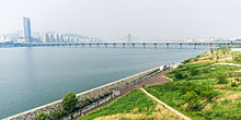
Jamsil Bridge
Appearance
| Jamsil Bridge | |
 Han River and Han River Park from Jamsil Bridge | |
| Korean name | |
|---|---|
| Hangul | |
| Hanja | |
| Revised Romanization | Jamsil Daegyo |
| McCune–Reischauer | Chamsil Taegyo |
The Jamsil Bridge crosses the Han River in South Korea and connects the districts of Songpa-gu and Gwangjin-gu. Completed in 1972, it is the 6th bridge to be constructed over the Han River.[1]
References
- ^ 잠실대교 [ 蠶室大橋 ]. Doopedia (in Korean). Naver. Retrieved 18 January 2014.
