Hammond's Knoll
Appearance
Hammond's Knoll | |
|---|---|
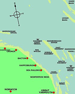
 Location map of Hammond's Knoll (right edge of map) | |
 | |
| Coordinates: 52°52′N 1°55′E / 52.867°N 1.917°E | |
| Location | Southern North Sea |
Hammond's Knoll is a 6-mile (9.7 km) long sandbank off the coast of Norfolk, England at Happisburgh, to the east of Haisborough Sands. The sandbank at low tide has a depth of 6 fathoms (11 m) at each end, and 3 fathoms (5.5 m) in the centre. The sandbank has lighted buoys at its north and east ends.
Ships wrecked on Hammond's Knoll
Some of the ships wrecked here include:
- HMS Invincible - 1801 with the loss of 400 lives.
- Galatea - 1898
- SS English Trader - 1941[1]
See also
- Haisborough Sands - nearby sandbank, similarly treacherous
- Scroby Sands
References
- ^ Jolly, Cyril (1988). The Loss of the English Trader. Acorn Editions. ISBN 0-906554-06-3.
