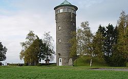
Buurgplaatz
Appearance

Buurgplaatz (alternate names: Buergplaatz, Burrigplatz, Burgplatz, Buergplaz zu Huldang) is a hill in the commune of Troisvierges, in northern Luxembourg. The 559-metre-high (1,834 ft) summit lies within the Oesling region at 50°09′41″N 6°01′41″E / 50.1615°N 6.0281°E.[1]

It is often erroneously considered the highest point in Luxembourg (so much so that there is a plaque on the summit celebrating as such). Actually, it is the second highest, after Kneiff at 560 m (1,840 ft).[2]
References
- ^ "US Gazetteer files: 2010, 2000, and 1990". United States Census Bureau. 2011-02-12. Retrieved 2011-04-23.
- ^ ACT (Administration du Cadastre et de la Topographie) Regional Map R1 Clervaux - Huldange 1:20000 (2003) shows 'Kneiff' at 560m and 'Buergplaz' at 559m.
Wikimedia Commons has media related to Burgplatz (Luxembourg).
