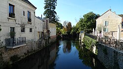
Grand Morin
Appearance
| Grand Morin | |
|---|---|
 | |
| Location | |
| Country | France |
| Physical characteristics | |
| Source | |
| • location | Champagne |
| Mouth | |
• location | Marne |
• coordinates | 48°54′1″N 2°49′50″E / 48.90028°N 2.83056°E |
| Length | 118 km (73 mi) |
| Basin size | 1,180 km2 (460 sq mi) |
| Basin features | |
| Progression | Marne→ Seine→ English Channel |
The Grand Morin is a 118-kilometre (73 mi) long river in France, left tributary of the Marne. Its source is near the village of Lachy. Its course crosses the departments of Marne and Seine-et-Marne. It flows westwards through the towns of Esternay, La Ferté-Gaucher, Coulommiers and Crécy-la-Chapelle, finally flowing into the Marne in Esbly.
Its main tributary is the Aubetin.
References
Wikimedia Commons has media related to Grand Morin.
