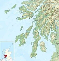
St Catherines, Argyll
Appearance
This article needs additional citations for verification. (December 2016) |
St Catherines
| |
|---|---|
 Loch Fyne Cottage at south western boundary of village beside disused loch road. | |
Location within Argyll and Bute | |
| OS grid reference | NN 12200 07300 |
| Council area |
|
| Lieutenancy area |
|
| Country | Scotland |
| Sovereign state | United Kingdom |
| Post town | DUNOON, ARGYLL |
| Postcode district | PA25 |
| Dialling code | 01499 |
| UK Parliament |
|
| Scottish Parliament |
|
St Catherines; (Scottish Gaelic: Cill Chaitrìona) is a village, on the Cowal peninsula in Argyll and Bute, Scottish Highlands. It is located on the banks of Loch Fyne opposite Inveraray and is served by the A815 road.
The old Ferry Inn, in St. Catherines is on the buildings at risk register of Scotland.[1]
The remains of St Catherine's Chapel and Burial Ground. Now only foundations remain of the chapel.[2]


References
- ^ "The Old Ferry Inn, St Catherines - Buildings at Risk Register".
- ^ "St Catherines, St Catherine's Chapel And Burial Ground". Canmore. Retrieved 14 December 2016.
External links
- Map sources for St Catherines, Argyll
Wikimedia Commons has media related to St Catherines, Argyll and Bute.

