
Transylvanian Plain
The Transylvanian Plain (Romanian: Câmpia Transilvaniei, Hungarian: Mezőség) is an ethnogeographical area in Transylvania, Romania, located between the Someş River and the Mureş River.
The Transylvanian Plain can be divided into two parts: a hilly one in the North-East and a plain one in South and West.
Some important villages of Câmpia Transilvaniei are Sic (a former salt-mining town), Mociu, Jucu, Band, Suatu and Unguraş.
Images
-
 Reformed Church in Beclean
 -
-
 Ceuaşu de Câmpie Reformed church and bell tower
 -
 Rascruci Banffy castle
 -
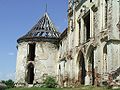
 Câmpeniţa Reformed Church
 -
 Kornis Castle in Manastirea, Cluj
 -
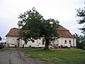 Voivodeni castle


External links
46°54′N 24°09′E / 46.900°N 24.150°E
This Romanian location article is a stub. You can help Wikipedia by expanding it. |
This Romania-related article is a stub. You can help Wikipedia by expanding it. |